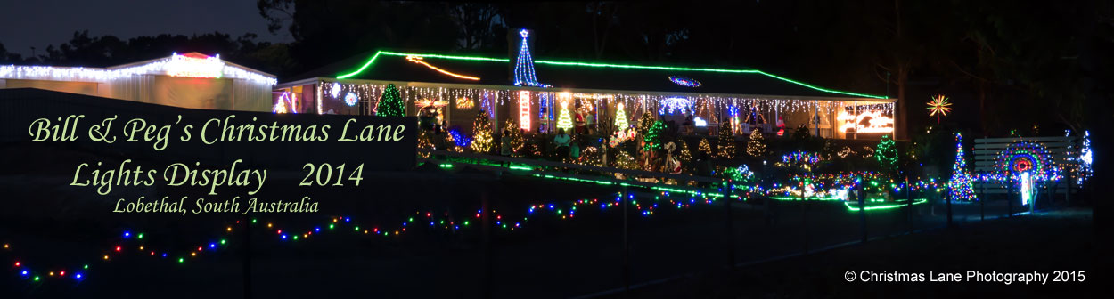
Lobethal, Bill & Peg, Christmas Lights Display, 5 Christmas Lane


|
Christmas is the Time of Year When Heaven Touches Earth(Anon.)
Lobethal, S.A., Australia
LOBETHAL (Meaning Valley of Praise) is set in the picturesque Adelaide Hills
about 40km SE of Adelaide, South Australia, Australia.
It was first settled by 18 families of Prussian Lutherans who were lead to the district by their pastor (Pastor G. D. Fritzsche) in 1842.
At the close of an open-air Thanksgiving Service on the 4th of May 1842 Pastor Fritzsche, The Founder of Lobethal, quoted the 26th verse of the 20th chapter of the Second Book of Chronicles:
"Am vierten Tage aber Kamen sie zusammen in Lobethal: denn darselbst lobten sie den Herrn. Daher heisset die
Stätte Lobethal, bis auf diesen Tag."
"And on the fourth day assembled themselves in Lobethal: for here they blessed the Lord."
To this day Lobethal has remained rich in the history of its German pioneers.
Since the 1940's,it has been presenting a Christmas Lights Display which has become the largest in the Southern Hemisphere.
Each year from the 2nd Sunday in December until New Years Eave the whole town "lights up" with a variety of spectacular Christmas Displays.
A little trivia:
The popular smallgoods FRITZ (peculiar to South Australia), was named after Fritz Eisenberg, an early butcher and sausage maker, who first made it in his Lobethal Main Street shop.
The shop, which was built in the mid 19th century and added to in the late 19th century, still remains and is now a private home.
The famous Onkaparinga Woollen blankets were originally made in Lobethal, and the site is now used as a Business Incubator.
The Lutheran Manse, built for pastor Dr. Loessel in 1867, was the first two storey built in Lobethal, and is now used as a Christian Book Shop, and teachers residence.
Behind the Manse is the original Lutheran Church, built in 1843-1845,for Pastor Fritzsche, and known as "Zum Weinberge Christi" ["To the Vineyard of Christ"].
It is the oldest Lutheran Church, still being used, in Australia.
Between the old Church and the Manse is a Museum, which is built over the original Lutheran College, which was built in 1845 by Pastor Fritzsche,
and was the first seminary built in Australia. The Museum contains much memorabilia and early artefacts.
The "Lovers Trees"
Behind the church is Pastor Frizsche's grave and nearby Lovers Trees.
It is said that in the early days of Lobethal's, settlement two young lovers were to be married,
however a week before the wedding the bride-to-be died,and was buried near the church.
The bridegroom was devastated, and pined away, dieing of a broken heart a month later.
He was buried next to his wife-to-be and they shared the same tombstone.
A short time later, two pine trees began to grow above their graves, with there branches intertwined.
Today these two trees still stand as a tribute to their love and are over 65feet tall.
There are many old buildings and reminders of Lobethal's early history that can be viewed around the town.
These photos from our front yard depict one of the rare occasions that it has snowed in Lobethal |
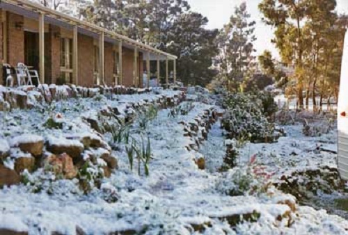
Snow at Lobethal 18th August 1996.
Photo Peg & Bill Chartres' collection Circa 1996 | 
Snow at Lobethal 18th August 1996.
Photo Peg & Bill Chartres' collection Circa 1996 | 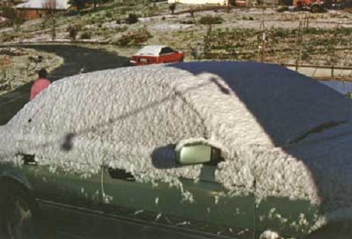
Photo snow at 18th August 1996.
Photo Peg & Bill Chartres' collection Circa 1996 |
Snow at Lobethal 18th August 1996.
Photo Peg & Bill Chartres' collection Circa 1996 | 
Snow at Lobethal 18th August 1996.
Photo Peg & Bill Chartres' collection Circa 1996 | 
Photo snow at 18th August 1996.
Photo Peg & Bill Chartres' collection Circa 1996 |

Visit our other Pages
Enjoy the Christmas Spirit through out the year.
Come and visit our display for a wonderful Christmas experience,
or email us with your thoughts about our Web Site.
we would love to hear from you.
e-mail us
Best Wishes, Bill & Peg

Come and visit our display for a wonderful Christmas experience,
or email us with your thoughts about our Web Site.
we would love to hear from you.
 |
Best Wishes, Bill & Peg
Our original site was created in March 1988,
and we moved to our own Domain in November 2014.